Buffalo Municipal Housing Authority Report Maps

Collection Owner:
Cover Image:
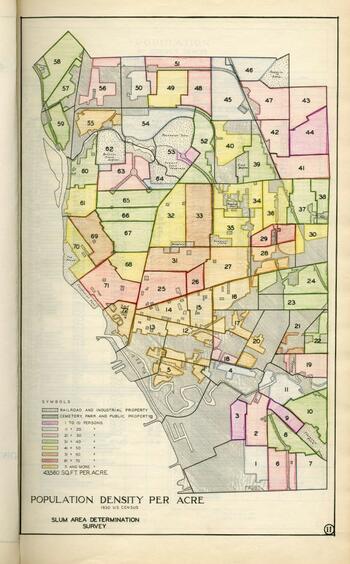
Buffalo Municipal Housing Authority Report Maps
Population Density per Acre - Image Source

Collection Facts

Extent:
30
Dates of Original:
1935

Historical Context

This collection maps selected from a Buffalo Municipal Housing Authority Report published in 1935. The report is a study of which communities in the city qualify as slum areas. In order to establish this, it contains information about the structural integrity of city housing, social welfare, and the economic status of the citizens. The study was considered essential in obtaining funding from the Federal Emergency Administration of Public Works in order to eliminate the slum areas of the city and provide low cost housing for the citizens of Buffalo.
These maps offer important historical and genealogical information about the City of Buffalo including: population density, population changes, the distribution of ethnic groups, the distribution of those in social welfare programs, major crime, cases of venereal diseases, Buffalo City Hospital Bed Patients, the Distribution of parks, City and public and parochial school playgrounds, location of churches, the distribution of Schools, and the councilmanic districts and wards of the City.

Scope of Collection

This collection contains several maps selected from a Buffalo Municipal Housing Authority Report published in 1935.

The full text of the 1935 report is available from Archive.org